
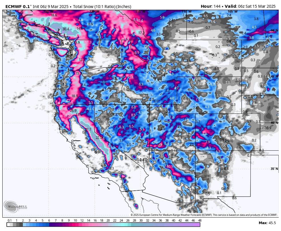
SUMMARY
A potent series of storms is hammering the West this week, headlined by massive Sierra dumps reaching 2–4 feet of fluffy snow. The Pacific Northwest and Rockies (Utah, Colorado, and the Northern Rockies) also score fresh powder, though amounts vary. Bottom line: multiple chase-worthy days line up from midweek onward—grab your snorkel!
This post is sponsored by Selkirk Powder, which offers ski touring trips and avalanche courses in northern Idaho. This region is in for a treat this week with extended snow likely into next week. Please check out Selkirk Powder if you want to ride crowd-less powder in the pristine wilderness northwest of Sandpoint, Idaho, near Priest Lake. They still have open slots. Mention Powderchasers for free swag!
CHASE FORECAST (DAY-BY-DAY)
Monday (Mar 10)
- Pacific Northwest: Up to 9" overnight into Monday at Baker and Stevens Pass (moderate-density, ~SLR 11), with ~3–7" at Snoqualmie and 2-5" at Crystal. If you’re craving a Monday morning shred, Stevens Pass or Baker that likley will have the highest totals.
- Everywhere Else: Mostly dry or minimal new snow—no real chase targets.
Tuesday (Mar 11)
- Pacific Northwest & California: Light leftovers in the morning aren’t worth the chase. The real action begins Tuesday night in many areas—hold off until midweek.
- Utah, Colorado, Northern Rockies: Quiet and dry overall.
Wednesday (Mar 12)
- California: An early round hits the Sierra Tuesday night into Wednesday. Best bet is Kirkwood or Sugar Bowlwith ~4–7" by Wednesday morning (SLR ~8–10, moderate density). Not enormous yet, but enough for a fun day. Strong winds Wednesday will keep upper lifts closed.
- Pacific Northwest: 3–5" at Crystal and Mt. Bachelor for a Wednesday morning refresh (SLR near 10). Stevensand Snoqualmie see lighter totals (~2–3"), still a decent midweek tune-up.
- Utah: Snow arrives late Wednesday night, so Wednesday daytime remains mostly dry.
- Northern Rockies & Colorado: Limited new snow—wait for bigger storms later in the week.
Thursday (Mar 13)
- California: Huge overnight dumps slam the Sierra. By Thursday morning, Kirkwood, Sugar Bowl, and Mammoth can see 10–25" fresh from Wednesday night alone (SLR ~11–16). Expect snorkel-worthy conditions, especially above 7,000 ft. Windy early, but epic deep turns once lifts spin at many areas. Winds decreasing and colder.
- Utah: Storm starts late Wednesday night. Look for Alta/Snowbird, Solitude/Brighton to pick up ~5–9" by Thursday afternoon (initially a bit denser, then fluffier as temps drop).
- Pacific Northwest: Another modest refresh—Mt. Bachelor could grab 3–5" by Thursday afternoon (SLR ~13–14). Not as huge as California but still soft turns.
- Northern Rockies: Jackson Hole sees ~3–5" total by Thursday evening (SLR ~9–10). Decent but overshadowed by bigger dumps elsewhere.
- Colorado: Storm remains mostly inbound for Thursday night. Daytime is still a teaser, aside from a dusting in southwestern mountains.
Friday (Mar 14)
- California: Another round of overnight snowfall with 3–6+" new at places like Kirkwood and Mammoth (SLR ~15–17). Not quite as massive as Thursday but still high-quality fluff.
- Utah: Major overnight dump: Alta/Snowbird could see 9-16" by first chair Friday (SLR ~15+), especially from that juicy Thursday-night hit. Other areas near Ogden and PCMR in the 7-14 inch range Friday morning. Many options in Utah.
- Colorado: Finally lighting up big, especially in the southern resorts. Wolf Creek wakes up to 8–17" by Friday midday (SLR 14–18+). That’s a full-on snorkel scenario for southwestern Colorado.
- Central mountains (Crested Butte, Aspen/Snowmass) should see more modest but still respectable freshies in the 3–6" range by midday. Telluride is a strong contender due too NW winds that often favor the North San Juan Range. 'Steamboat may also do well as moisture funnels up from Rifle to Craig. I-70 stays in the 5-10 inch range.
- Northern Rockies: Jackson Hole picks up ~2–5" overnight, plus a bit more Friday. Not as deep as UT/CO, but still decent, especially with colder temps preserving snow quality.
Saturday (Mar 15)
- California: Storm cycle gradually tapers by Saturday, but leftover totals could be 3–8" more (from Friday night). Expect top-tier conditions across the Sierra from the multi-day onslaught.
- Utah: Another few inches (2–5") in the Cottonwoods by Saturday morning (SLR 17+ = blower). Not huge, but super-fluffy top-ups on a deep base.
- Colorado: Many mountains pick up a final refresh overnight Friday into Saturday (1–3" new). Not monstrous, but with leftover cold air, Friday’s powder remains in good shape for Saturday riding. Vail/Beaver Creek could see ~2–3" fluff on top of Friday’s snow.
- Northern Rockies & PNW: Some continued snow in Oregon (e.g., Mt. Bachelor 3–7"), and scattered light snow across Idaho/Montana ranges. For the truly deep day, though, look to the Sierra or southwestern Colorado.
KEY POINTS
-
Good:
- Sierra crushes it with multiple feet of snow at great SLRs—truly snorkel-level by Thursday/Friday.
- Utah’s Cottonwoods and southwestern Colorado go big Thursday night into Friday, with ultra-fluffy densities.
- Colder air post-storm helps preserve powder in many regions.
-
Bad:
- Strong winds in the Sierra on Wednesday may affect upper-mountain lifts, and breezy conditions in Utah/Colorado could cause drifting.
- Snow levels start higher in some spots (e.g., early Wednesday in UT), leading to denser snow at the onset.
-
Wildcards:
- Embedded thunderstorms in parts of the Sierra on Thursday could amplify snowfall rates.
- Next weekend’s storms hold some uncertainty in exact totals and wind intensities, especially for the PNW and Northern Rockies.
REGION-BY-REGION DETAILS
California (Tahoe/Mammoth)

A classic Sierra storm train arrives midweek. Snow starts lightly Tuesday night, then intensifies all day Wednesday into Thursday, with heavy, high-ratio snow (SLR frequently 12–17). By Thursday morning, upper elevations (above ~5,000–5,500 ft) could see well over a foot—resorts like Kirkwood, Sugar Bowl, Palisades Tahoe, and Mammoth likely measure 2+ feet by Friday. Snow levels crash to ~3,000 ft by Thursday night, setting up widespread coverage. Winds ramp up Wednesday (gusts 50+ mph), possibly limiting some lifts early, but conditions will be all-time once the storm settles.
A follow-up system Friday into early Saturday continues the conveyor belt of cold, deep snow. Expect an additional 1–2 feet in spots, especially near the Sierra crest. With strong storms lined up behind, the outlook remains snowy through the weekend—classic big-dump Sierra pattern.
Pacific Northwest

A steady stream of moisture continues. Early in the week, moderate snowfall hits the Washington Cascades (best Sunday night into Monday for Stevens Pass). Systems roll through midweek, bringing scattered accumulations (~3–6" per wave) to Crystal, Snoqualmie, and the Oregon Cascades. Mt. Bachelor and Timberline see repeated hits with respectable totals into Friday/Saturday. Snow levels generally range 2,000–4,000 ft, dipping lower by Thursday, so coverage stays decent. Winds could be gusty in typical Cascade style, but the real story is consistent, moderate dumps—no single monstrous event, but enough for repeated powder refreshes.
Utah

High pressure dominates through Tuesday, but a significant storm arrives Wednesday night. Initially, snow levels hover around 6,000–6,500 ft, so early snow might be slightly denser in places like Park City. As colder air arrives late Thursday, the Cottonwoods (e.g., Alta/Snowbird, Solitude/Brighton) see 5–10" overnight. Expect deeper pockets by Friday morning (6–12" possible) with very high SLR (15+), meaning blower conditions. Winds from the southwest become strong Wednesday, then shift northwesterly by Friday, enhancing lake-effect/lifted upslope in prime spots. Southern Utah mountains (e.g., Eagle Point) also do well Friday, with chilly temps preserving the freshies into Saturday.
Northern Rockies (ID/MT/WY)

Spotty storms roll through in waves. The strongest hits arrive mid to late week, favoring the Idaho mountains (Brundage, Bogus Basin) Wednesday–Friday and western Wyoming/northwest Montana from late Wednesday into Thursday. Totals generally run in the 3–8" range each storm cycle, but a few pockets—like Grand Targhee or Schweitzer—could see 10"+ if localized bands set up. Selkirk Powder Guides will score too. Snow densities vary from moderate (~8–12 SLR) to quite fluffy (14+) by Friday. Watch for wind impacts near ridgelines, especially Thursday, but overall conditions should be good, especially heading into the weekend.
Colorado

Early to midweek stays mostly dry except for a few light showers in the southern mountains. The main event blasts in Thursday night through Friday, focusing on southwestern resorts like Wolf Creek—they could see 1–1.5 feet or more of cold smoke by Friday midday. Elsewhere, the central and northern mountains (Crested Butte, Aspen/Snowmass, Winter Park, etc.) pick up moderate totals (3–8") through Friday, with potential for another few inches by Saturday. SLR values in the high teens indicate very fluffy snow—watch for wind scouring on high ridges. By Saturday, a taper in precipitation leaves behind excellent packed-powder conditions for the weekend.
EXTENDED OUTLOOK
A busy pattern continues into the weekend and possibly beyond. The Sierra could see another storm Friday–Saturday, while the PNW and northern Rockies remain unsettled with periodic snowfall. Confidence is moderate that winter’s grip will stay locked across the West, so expect more chances for deep turns and periodic refreshes heading into next week.


