Our last forecasts downtrended the New Mexico Storm, especially Taos last weekend, essentially in line with the European models that showed a skunk hole. That system dropped south and provided 16 inches of fresh powder for Ski Apache near Ruidoso (Southern New Mexico). We were surprised to see Angel Fire come up short. Storms with East or SE winds are often not winners for Taos and often can be decent for Ski Santa Fe and Angel Fire. The short-term high-resolution models did well on that storm while the American GFS deterministic model struggled. Ski Santa Fe grabbed 10 inches, which was on track for our forecast.
New England/New York
The East Coast grabs a fast-moving storm that will impact metro areas of New York, Connecticut, and Massachusetts. This storm will start above-freezing Monday night with slight cooling Tuesday morning during the peak snowfall intensity (32 near the coast). Areas of the Catskills and just inland from the coast might see 5-10 inches, including metro areas. This will be very dense snow with temps rising above freezing again by midday Tuesday. Nashoba and Wachusett including the Berkshires should all pick up 5-9 inches with less as you travel north into southern New Hampshire and Vermont.

Below: You can see temps Tuesday morning right around freezing along the coast where the heaviest precipitation will be falling (New York City). Temps are a bit warmer as you head towards the Cape and Boston but certainly cold enough for snowfall inland.

PNW
The Pacific Northwest grabbed a teaser on Sunday night with 7-8 inches on the telemetry for Mt Baker and 4-5 for Stevens. Less snow is falling to the south. Snow showers continue on Monday. Heavier snow is possible mid to late next week!
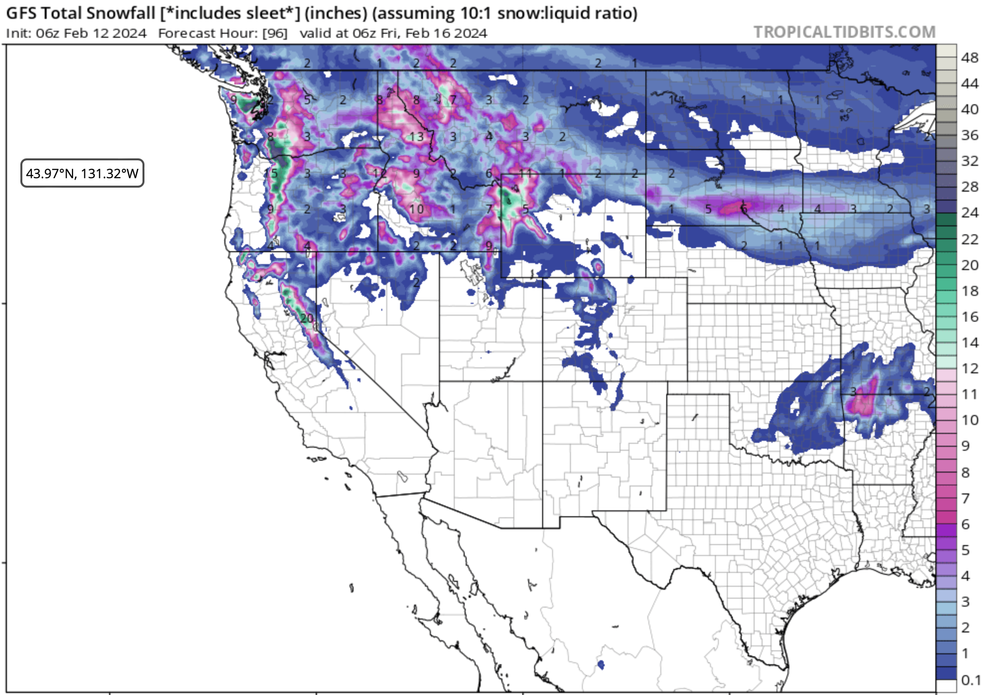
Below: Light snow is noted early this week for the PNW including the Panhandle of Idaho, Montana, and Wyoming. Snow intensity increases late Wednesday for the PNW and Thursday for the northern Rockies extending south to the Sierra. The mid to late-week storm will likely bring over 12 inches to many mountain ranges. Thus far the deepest chase picks might be in the Oregon Cascades, southern Washington (Crystal), Northern Sierra (Wildcard), Panhandle of Idaho, and the Tetons

Below: Total snowfall for the Cascades favoring Washington's southern and perhaps central regions and a good portion of Oregon later this week. Winds from the SW initially favor Mt Rainier and areas south of Crystal. Winds shift to the south at some point during this storm and can often funnel better totals into Crystal and even Mission Ridge (Need to be watched).

Rockies
Below: Significant snow is possible by mid to late week for the Tetons with moderate amounts for many areas of Montana. Colder temps will bring higher amounts than the models suggest below (10:1). Storm totals from Tuesday to Friday will likely be in the 15-20 inch range or higher.

Below: U. Of U. graph for JHMR showing continuous light snowfall rates this week peaking on February 14/15 (Wednesday/Thursday) with 15:1 snow ratios (1 inch of water= 15 inches of snow).

The Sierra should grab snowfall from Wednesday night to Thursday favoring the northern ranges of the lake. I have to put them down as a wildcard with decent confidence of 8-12 inches. This could change.

Below: Meanwhile back in New England a moderate storm will impact many ski areas later this week into Saturday (Map is 48-hour snowfall ending late Saturday).

Bottom Line: There is a lot to talk about. Chases might focus on the PNW, Sierra, or Northern Rockies. Remember that some areas have not had much snow so even chasing 5-11 inches might not deliver prime time. The sum totals will deliver healthy doses whereas our guess is that by the end of the week, many ski areas will be sitting in much better shape overall. What we like about this pattern, is it's colder up north where many storms have been either rain or simply low impact. While Utah got its share last week, areas north see better odds this week.
Help us out!
If you want to chase powder with Powderchasers sign up for the concierge package for the deepest resorts to chase to and 1:1 custom forecasting with our staff. Also, if you have read this far, please donate to continue receiving these free forecasts. We appreciate the community support. You won't regret chasing with our custom forecasts. We have new swag on the Powderchasers storefront and all larger donations include it at no charge.
Enjoy the powder, everyone! Remember, your deepest resort is not always the best chase. See you in the first chair somewhere on Monday.
Enjoy the powder, everyone!
Powderchaser Steve @powderchasersteve on Instagram
Powderchaser Steve


