Summary:
Summer-like temps will come to an end later this week for much of the northern Rockies with a sharp cold front, northerly winds, and some moderate to perhaps heavier snow for some ski areas.
Forecast:
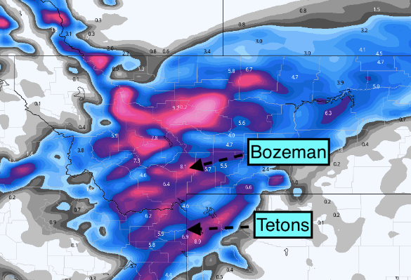
Good afternoon Powder Lovers, and in the case of the past few days mountain biking with temps in the Denver area reaching 85 degrees Tuesday (Record). I was able to sample North Table Mountian for a short ride Tuesday and Buffalo Creek on Wednesday (Dry). The action over the next 3 days will be active with a cold front impacting Montana, Wyoming, and Colorado primarily. Cold air and moderate to heavy snow is likely in the mountain ranges near Showdown and Great Divide (Central Montana) beginning late Wednesday night and continuing into Thursday night. The models show double digits are likely. Showdown is closed for the season but Great Divide opens this Saturday (Might be worth a chase).
Below: Powderchasersteve at Buffalo Creek for a lunch break on Wednesday (Surprised to see it dry). Check out the lowest offering from Ikon for next season below.

less snow will fall further south, but the models are showing some decent totals for Bridger Bowl (closed) and a bit less towards Big Sky which is still open. Friday might be the best bet as far as timing. Temps are in the lower to mid-40s at Big Sky currently so the moderate totals Thursday into Friday and much colder temps might bring very high-quality pow on top of a firm layer below. Might not be an ideal long-term chase.
The Tetons grab moderate snowfall (JHMR is closed with Targhee open) primarily early Thursday morning through late PM. Amounts will likely range from 4-9 inches on Teton Pass. There is flux in the models even as of Wednesday evening. The latest short-term high-resolution models are showing higher amounts while the European much less. Expect the unexpected for Thursday morning (Could be a deepish powder day on the Pass or even the Ghee) with some up or downside potential (4-10 inch range through Thursday afternoon).
Below: Central Montana looks the deepest with moderate snow further south into the Bozeman area and into the Tetons. Some models show higher amounts near Teton Pass (Wednesday night to Thursday PM)

Finally, for Colorado, the peak periods of snowfall appear to be Friday early PM to Saturday. We mentioned the Front Range Resorts last week with the models still favoring areas from Loveland Pass, A-Basin, Eldora, Breckenridge, and perhaps a bit higher amounts towards Winter Park. NW flow on the western side of Colorado could bring moderate totals for the Elk Range (Aspen) extending into the northern ranges of the San Juan Mountains (Telluride an outside wildcard). The peak period for riding pow will be the last chair Friday but more likely the first chair on Saturday. Look for some decent totals closest to Denver. Winds are Northerly near the Front Range bringing morning lows in the 30s for Denver (Might get some snow on the grassy surfaces), and conditions at resorts will be firm underneath (Maybe stick to some groomers with a bit of face-shot snow on top). Keystone can also do well with Northerly winds.
Below: Front Range resorts seem favored with this storm, but out west with NW flow it's possible some sneak-up surprises in the Elk Range or Vail Pass, Primary powder late Friday to Saturday.

While we are happy to see these warmer temps and some trail riding, we always look forward to the isolated times in the spring to ride powder. The extended look is active.
Extended Pow:
The extended look is cold and active for the PNW and Sierra. Another storm is likely for the coastal ranges of BC (Whistler) later this week or early next. That system might drop south along the coast and provide additional snow for the PNW and Sierra. Looking out for cold air, there are several more fronts noted next week. The operational models want to keep an active period of moderate storms every 48 hours with a larger system noted for late next weekend.
Below: Unseasonably cold air is noted for the PNW and Sierra early next week (April 18). Some snow is likely with this cold front. These temps are more representative of a January storm (10K in C).

Below: Low pressure is noted off the Oregon Coast early next week (April 18th) which might push some moisture south to the Sierra and TBD on amounts for the Rockies.

Below: Low pressure late next week or next weekend could bring a more significant storm to the Sierra. Are we flipping back to winter? Low confidence this far out. (Map is April 23rd).

Powderchasers is going to be wrapping up its regular posts in the next few weeks. Please take an opportunity to support us! We are always looking for new sponsors for the website so please reach out to us at powderchasersmedia@gmail.com to be highlighted next season.
Don't forget to join our Concierge program for custom chase forecasts or donate here. Donations keep our free forecasts going. Members rarely miss the deepest days. If you scored powder based on our forecasts (We run into you when we chase) please donate for powder! If you read this far you qualify!
Powderchaser Steve - @powderchasersteve on Instagram- See you on the first chair somewhere.


