
Summary:
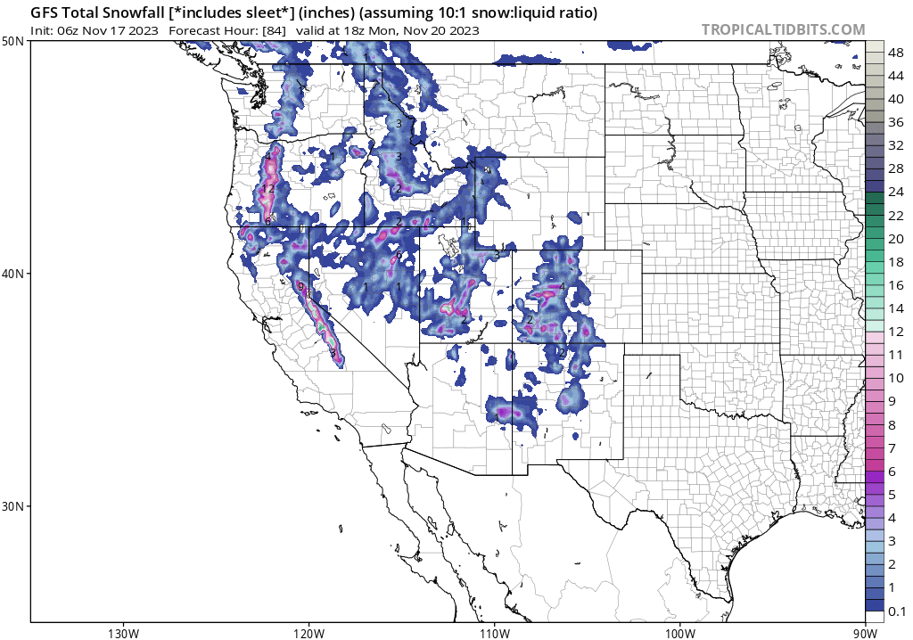
This is not an easy forecast with so many variables and even short-term model differences. We are feeling good about a decent event for the Sierra (Southern areas are favored), and Oregon with a bit of skepticism for Washington. Northern Utah could boom big time but also kinda bust. Colorado and New Mexico next.
ANNOUNCEMENT: Please join our concierge program to support powderchasers. This program provides 1:1 forecasting, chase locations, and custom trip planning to get you in the deepest snow of the season. You can also donate on our website or purchase some swag to support us.
Below: Current Moisture (Percent of average) SWE (If you melted the snow) is very gloomy for many areas aside from the PNW. The PNW water totals have mainly been at the peaks or above the elevation of many ski areas (Water). The PNW and Canada really highlight here as the wetter areas thus far this season. Areas in the southern Rockies are sitting near 0% in some cases. This is about to change, but it will take several storms to put a real dent in these numbers.

Sierra Pow:
In the past few days, we have increased the water totals for the Sierra. The models agree that the heaviest moisture will occur after midnight Friday through Saturday evening. This storm is warm with snow levels around 8,000 feet initially decreasing significantly to lake level by Sunday morning as moisture weans. The models are advertising 8-11 inches of snow for the Sierra Crest (Western side of the lake above 8,000 feet). There are still differences in pinpointing the deepest snow with some emphasis on areas from Kirkwood and south. It is likely that southern areas including Mammoth or June end up with the highest totals. Bottom line: Decent moisture that starts out warm and finishes cold. Upper elevations will see decent snow totals perhaps along the entire Sierra Crest. Lowland snow is likely late Saturday night or early Sunday as temps lower significantly (Light snow for the passes and bases).
Below: The American model is optimistic for a widespread event for the majority of the Sierra Crest in California including most resorts in the core of the Tahoe Basin (Widespread totals of 6-11 inches above 8,000 feet). The snow level will be lower by Sunday morning bringing some light snow to the bases. Most of the snowfall from this storm will mainly impact mid and upper elevations until the tail end late Saturday or early Sunday.

Below: The European Model pushes more moisture to the southern end of the lake and the southern Sierra (Mammoth or June Mountain). Mammoth might benefit most due to the higher base elevations. Keep an eye out on Kirkwood.

Below Very cold temps (14F) at 10K feet by Sunday morning as light moisture lingers over the Sierra. Some light snow will be falling at lake level but most of the moisture is east of the Sierra ranges. The highest totals will be above 8,000 feet until Sunday.

Pacific Northwest Powder
The models have pushed the heaviest moisture south into Oregon where our highest confidence is currently. Short-term models still depict a decent event for areas near Stevens Pass and south into Crystal, but the majority of precipitation will likely land further south. NW and Westerly flow will favor the central and southern Cascades versus areas further north towards Baker.
Caveat: As of Friday morning the short-term models (Normally we have higher confidence here) and Canadian Deterministic are showing a widespread event in Washington and Oregon with the American, and Euro all pushing the moisture further south into Oregon. There is still some boom or bust potential. W-NW flow can be good for many areas of western Cascades favoring central and southern regions. The best guess is 5-11 inches into the Oregon Cascades (Timberline, Mt Hood, Bachelor) and 3-7 inches in areas of Washington from Stevens Pass and south. Chase south for the highest odds (Nothing is open).
Utah Boom Or Bust?
There are very large differences in the models that could land 4-9 inches for northern Utah or 11-20. The low ejecting from California may cut off in Nevada and drop south of the Wasatch. Or, it may progress east and crank out significant snow totals for most of northern Utah. The storm is coming in pieces with a warm SW flow initially on Saturday kicking off high-elevation snow showers for BCC, and areas north towards Ogden (Snow levels will be above 8500 feet).
By daybreak Sunday the winds veer NW with a cold front lowering snow levels to the bases of many resorts. However, the NW flow (Ideal wind direction for most of northern Utah) veers due northerly by mid-morning possibly shutting off the highest orographic (Terrain-based forcing of cold air and moisture) lift. This is a really tricky storm. The American model takes the coldest air south towards central Utah and southern zones (Eagle Point, Brian Head). This model also depicts a 4-8 inch event for areas of northern Utah above 8,000 feet. The European Model is more optimistic as well as some of the short-term models that all show much higher liquid totals. Some models show upwards of 20 inches for the Cottonwoods. We are a bit worried about northerly winds for the Wasatch (West, NW, SW is ideal for most areas). This might actually kick off a surprise towards Beaver (Logan area).
Below: American GFS is pessimistic for northern Utah taking the coldest air and low south of the Wasatch to the central and southern regions. You can see the coldest temps on Sunday lingering over Nevada pushing into central Utah while areas north remain warmer. This will result in less snow for the northern Wasatch and better odds towards Eagle Point. This is the bust scenario for northern Utah and a boom for the southern areas.

Below: The Canadian deterministic model and the short-term NAM both show a much colder solution with good orographic lift for the Wasatch Range and heavier snowfall, especially on Sunday with this front (The boom solution for northern Utah). This could result in significant snowfall for the Wasatch Front.

Below: U. of U. ensembles show a wide range of solutions for the Cottonwoods between 10 and 30 inches. Since the American model is so pessimistic while others are a bit more optimistic we are trending the middle road at 12-16 inches for the Cottonwoods and 8-11 inches for the upper elevations for Park City peaking Sunday. The storm will be very warm initially with valley rain until the coldest air arrives Sunday. There is upside and downside bust potential with wide variances in the models. You can see the wide differences in the darker lines below (Low confidence).

Below: Similar totals at Park City Summits being depicted as the Cottonwoods (U.of U). (10-20 inches). There is still bust potential depending on the model. 
Colorado/New Mexico
We are most optimistic for the far western corridor of Colorado towards Grand Junction (Powderhorn), and extending south towards Montrose, Telluride, Durango, and perhaps Wolf Creek. Peak snowfall will be from late Saturday (Warm) to Monday (Cooling trend late Sunday). Winds are SW initially (Good for the southern mountains) and veer northerly by Sunday afternoon (Might be okay for the northern San Juans (Telluride). The storm will likely favor areas of the San Juan Range with lower-elevation rain and high-elevation snow. There are still many puzzles to connect and it's possible that areas west near Grand Junction, or even areas outside the ranges of the ski areas score the most moisture. Keep an eye out for New Mexico. Areas east on I-70 will see lower snow totals.
Below: Total moisture through Monday morning for Colorado favoring western areas of the State. The southern mountains might do best.

What a long and tricky forecast. Our confidence will hopefully improve for the next post on Saturday.
The extended brings high pressure back into the west next week with another storm possible after Thanksgiving.
Follow my photo adventures, world travel, and passion for snow on Instagram @powderchasersteve
Enjoy the snow everyone! Don't forget to donate or join the concierge program.
Powderchaser Steve


