
A blockbuster string of snow events is lining up for the western US, bringing the deepest powder to the Pacific Northwest first and then spreading inland. Overall, chase prospects are outstanding this week, with Timberline likely topping the charts through Tuesday or Wednesday and heavy multi-day accumulations also targeting parts of Idaho, Wyoming, and northern Utah. If you want the absolute deepest powder, prioritize the Pacific Northwest or western Wyoming/Idaho first, then look to Utah’s Cottonwoods for midweek snow refresh, and finally, catch freshening conditions into Colorado Monday night through Tuesday. Each region is broken down below, so pick your spots and get after it!
This post is sponsored by Selkirk Powder, which offers ski touring trips and avalanche courses in northern Idaho. This region has received lots of snow over the past five days and is in for a treat this week with two additional storm systems. Please check out Selkirk Powder if you want to ride crowd-less powder in the pristine wilderness northwest of Sandpoint, Idaho, near Priest Lake. They still have open slots. Mention Powderchasers for free swag!
5-day totals
Last week and this weekend were active across the west. Let's take a look at some of the deepest 5-day totals around the West:
- Mt Rose: 60"
- Mammoth: 52"
- Northstar: 41"
- Sugar Bowl: 41"
- Silverton: 40"
- Vail: 39"
- Snowbird: 38"
- Alta: 37"
- Crested Butte: 37"
- Brighton: 35"
- Aspen Highlands: 35"
- Palisades Tahoe: 35"
- Powder Mountain: 35"
- Steamboat: 35"
FORECAST
Pacific Northwest

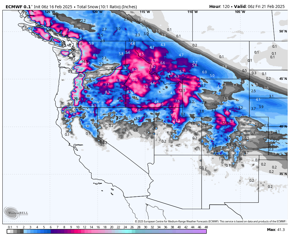
Above: multiple waves this week favor the southern Cascades, especially around Mt Hood.
PNW Chase Bottom Line: Target Sunday afternoon through Tuesday morning in the Washington and Oregon Cascades for the deepest new snow, especially above 4000 ft. Timberline, Bachelor, Stevens, Baker, and Snoqualmie Pass should see the deepest conditions, with Monday likely the deepest day. Then, consider a quick refresh if the midweek wave materializes. Stay flexible with travel to catch prime conditions at the highest-elevation resorts.
A pair of active frontal systems will bring multiple rounds of snow to the Pacific Northwest through midweek. A moist Pacific front moves inland into Monday, delivering widespread rain to lower elevations and heavy snow to the Cascades, where snow levels hover around 3500–4000 ft. By Monday, expect 1–2 feet (or even more in favored spots) for the higher elevations, especially near the passes.
From late Monday into Tuesday, additional upper-level waves keep snow showers going. Snow levels gradually lower to near 3000–3500 ft, maintaining decent coverage across the Cascades. Precipitation intensity should wane slightly by Tuesday afternoon, but continuous on-and-off mountain snow should be expected until then. Slightly milder air will work in from the coast by Tuesday night, potentially elevating snow levels again in the southern portion of the region.
Wednesday and Thursday bring another episode of unsettled weather. Although confidence varies, the midweek trough can produce another round of moderate to heavy Cascade snow. In the farther north of Washington, colder conditions hold snow levels in check, while southern areas of Oregon may see slightly higher snow lines. This midweek wave could bring an additional boost for places like Mt Bachelor and Timberline. This will largely feel like the same storm for Timberline, which should see relatively steady snow between the two events.
In the extended outlook, there are signals for drier weather to take hold late in the week. A ridge may develop offshore, lessening precipitation chances for the weekend. Some solutions still hint at more moisture sneaking in, but for now, plan on a drier and gradually warming regime by Friday or Saturday. Watch for potential surface inversions if skies clear for an extended time.
Medium/Long-Range: While late-week ridging suggests a quieter period, keep an eye out for a possible ridge breakdown next weekend or early the following week, which could return storms. The 6–10-day outlook leans drier overall, but that can change quickly depending on how the ridge evolves.
5-Day Resort Forecast Totals
- Timberline – 31–48” Sun (02/16) – Thu night (02/20)
- Mt Bachelor – 18–29” total (14–20” Sun (02/16) – Tue (02/18) + 4–9” Tue night (02/18) – Thu (02/20))
- Snoqualmie Pass – 15–25” total (11–16” Sun (02/16) – Tue (02/18) + 4–9” Tue night (02/18) – Thu night (02/20))
- Stevens Pass – 15–25” total (9–13” Sun (02/16) – Tue (02/18) + 6–12” Tue night (02/18) – Thu night (02/20))
- Crystal Mountain – 8–16” total (4–7” Sun (02/16) – Mon night (02/17) + 4–9” Tue night (02/18) – Thu (02/20))
- Mt Baker – 9–17” total (3–5” Sun (02/16) – Mon night (02/17) + 6–12” Tue night (02/18) – Thu night (02/20))
- Whistler – 4–9” total
Northern Rockies

Above: favorable snow pattern across the region, primarily favoring the Tetons and north-central Idaho.
Northern Rockies Chase Bottom Line: Sunday afternoon through Tuesday morning should offer the best shot at deep powder, with the Tetons (Jackson Hole, Grand Targhee) and areas like Bogus Basin or Brundage in Idaho favored for the most significant multi-day totals. Plan for deeper early-week conditions in southwestern Montana, with Big Sky and Bridger Bowl picking up a solid refresh. The best days likely fall on Monday and Tuesday morning in many spots. Selkirk Powder will be deep this week. Book a trip while seats are still available.
A moist westerly flow will keep snow across the region, including Idaho, western Montana, and northwestern Wyoming. Multiple energy impulses will rotate through from Sunday into early Tuesday, offering prolonged mountain snow. The heaviest snowfall rates will favor areas along the Idaho/Montana border and the Tetons and southwestern Montana ranges.
From Sunday night through Monday night, moderate to heavy snow is expected in the central mountains of Idaho and northwestern Wyoming. As Arctic air over northern Montana presses southward, snow and colder temperatures will expand across lower valleys in far northern sections. The tight temperature gradient sets up enhanced snowfall along and near the Continental Divide, plus the Montana/Idaho border. Travel impacts and slick roads will be the norm at mountain passes like Lookout Pass and Teton Pass.
By Tuesday, snow rates begin to taper, but expect showers to linger in favored upslope areas. Light accumulations could persist in mountain valleys under the cold, unsettled flow. Further west in Idaho, less intense precipitation continues through Tuesday morning, then gradually diminishes. Expect fairly frigid overnight lows across higher valleys, especially where fresh snowpack allows for good radiational cooling.
Late in the week, a ridge may briefly build, although some models suggest additional trough activity by mid-to-late week. With the pattern in flux, monitor conditions if you plan a chase. Additional waves could bring new snow to the Bitterroots and southwestern Montana around Wednesday–Thursday. Warmer air is possible heading into next weekend, though that warmth could be muted in deeper mountain valleys.
Medium/Long-Range: There is decent confidence that ridging could break in again around Wednesday or Thursday, bringing a new round of snow or partial dryness, depending on the exact track of the next trough. The 6–10 day outlook leans near to slightly cooler than average, with the potential for more storms if the ridge breaks down. Keep an eye on day-by-day changes.
5-Day Resort Forecast Totals
- Grand Targhee – 25–40” total (22–33” Sun (02/16) – Wed (02/19) + 3–7” Wed night (02/19) – Thu night (02/20))
- Jackson Hole – 19–29” total (17–24” Sun (02/16) – Tue night (02/18) + 2–5” Wed night (02/19) – Thu night (02/20))
- Bogus Basin – 14–23” total (10–15” Sun (02/16) – Tue (02/18) + 4–8” Wed (02/19) – Thu (02/20))
- Brundage – 12–20” total (9–14” Sun (02/16) – Tue night (02/18) + 3–6” Wed (02/19) – Thu (02/20))
- Big Sky – 10–17” total (8–12” Sun (02/16) – Tue night (02/18) + 2–5” Wed night (02/19) – Thu night (02/20))
- Bridger Bowl – 9–14” Sun (02/16) – Tue night (02/18)
- Schweitzer – 5–9” total (4–6” Sun (02/16) – Mon night (02/17) + 1–3” Wed (02/19) – Thu (02/20))
- Whitefish Mountain – 5–8” Sun (02/16) – Tue (02/18)
Utah

Above: ECMWF (left) and GFS (right) showing solid snowfall favoring the northern Wasatch. Areas along or north of I-80 (Beaver Mountain-Logan, Ogden area mountains) may have higher totals than the southern Wasatch (South of I-80).
Utah Chase Bottom Line: Sunday evening through early Tuesday should deliver solid powder for the northern Wasatch, with best conditions Monday afternoon into Tuesday. Another possible chase window is Wednesday night into Thursday if the next trough arrives robustly.
Shortwaves will hit northern Utah from Sunday through Tuesday, followed by another wave midweek. The first wave arrives today, spreading valley rain and mountain snow across north Utah. Snow levels initially sit around 5000 ft or higher but will drop late Monday into Tuesday. Precipitation tapers somewhat by Tuesday afternoon, though higher slopes in the northern Wasatch could see moderate accumulations through that period.
Monday’s best shot of more intense snowfall occurs with the cold front entering northern Utah. Winds pick up over ridgetops, and snow levels drop to near most valley floors by early Tuesday morning. Though moisture decreases late Monday night, lingering instability should keep showers in place. Plan on 6–12 inches or more across the northern Wasatch by Tuesday midday, with higher amounts possible in favored terrain.
A midweek trough arrives Wednesday into Thursday, potentially boosting totals further in the northern and central mountains. Forecast confidence varies, but many solutions highlight a swath of new moisture across the Wasatch and possibly the southern mountains. Initially, warmer air aloft may keep snow levels in the 6000–7000 ft range Wednesday before dropping again late in the storm. If that wave holds together, expect an extra round of powder days by late Thursday.
Late in the week, flow may become more zonal, or a ridge could build, trending drier into the weekend. Temperatures should begin to rebound, especially for lower elevations. New storms can quickly crash that party if the ridge is weaker than expected. Monitor updates if you’re planning a chase after Thursday.
Medium/Long-Range: Extended outlooks suggest a brief warmup by Friday and Saturday, though shortwaves could still graze the region. Watch for possible additional storms next weekend or early the following week if the pattern remains active across the broader West.
5-Day Resort Forecast Totals
- Alta/Snowbird – 10-20” total (11–16” Sun (02/16) – Tue night (02/18) + 5–12” Wed (02/19) – Thu night (02/20))
- Solitude/Brighton – 9-16” total (10–15” Sun (02/16) – Tue night (02/18) + 5–11” Wed (02/19) – Thu night (02/20))
- Powder Mountain – 12–20” total (8–13” Sun (02/16) – Tue night (02/18) + 4–10” Wed night (02/19) – Thu night (02/20))
- Beaver Mountain – 11–18” total (9–13” Sun (02/16) – Tue night (02/18) + 2–5” Wed night (02/19) – Thu night (02/20))
- Park City/Deer Valley – 9–17” total (6–9” Sun (02/16) – Tue night (02/18) + 3–8” Wed night (02/19) – Thu night (02/20))
- Eagle Point – 2–5” Wed night (02/19) – Thu night (02/20)
Colorado

Above: The ECMWF snowfall forecast shows a pattern strongly favoring the northern mountains. Look for Steamboat to be the winner this week.
Colorado Chase Bottom Line: Monday into Tuesday looks best for the central and northern mountains—Steamboat, Vail, Winter Park—where 1+ foot totals are possible by midweek. Steamboat looks best on Monday morning. Farther south, Wolf Creek and Telluride see more modest refreshes. Keep an eye on late-week possibilities if the next trough holds together. Front Range areas might see minor accumulations Monday night into Tuesday, but the cold will be the bigger story.
A quick-hitting system sets the stage for increasing mountain snow Sunday evening into Monday, mainly for the central and northern mountains. Periods of light snow continue through Monday night. Snow levels remain fairly low, so expect accumulations across passes like Rabbit Ears, Vail Pass, and Berthoud Pass. Colder air arrives late Monday into Tuesday over northeast Colorado, with the associated front bringing additional light snow east of the Continental Divide.
The most significant mountain snowfall arrives Monday afternoon through Tuesday morning, focusing on the northern and central zones. By Tuesday, look for roughly 6–12 inches in the higher terrain around Steamboat, Winter Park, and Vail. Farther south (e.g., San Juans), totals look lower overall, though a few inches are possible, especially in the northern San Juans near Telluride. Winds may be moderate at ridgetops but shouldn’t be extreme.
Another trough may cross the state by mid-to-late week, providing more snow potential for the high country. Model differences remain, but an additional wave Wednesday night or Thursday could yield fresh accumulations, especially across northern mountains. Then, a gradual warming trend is likely heading into the weekend, though well-covered slopes should linger in wintery shape.
Medium/Long-Range: Confidence is moderate for a short wave around Thursday. Once that wave passes, ridging could rebuild for a drier weekend. The 6–10 day outlook suggests gradually moderating temps, but the southern track could stay active—stay tuned for updates.
5-Day Resort Forecast Totals
- Steamboat – 16–27” total (13–20” Sun (02/16) – Wed (02/19) + 3–7” Wed night (02/19) – Thu night (02/20))
- Vail/Beaver Creek – 10–20” total (9–15” Sun (02/16) – Wed (02/19) + 1–5” Wed night (02/19) – Thu night (02/20))
- Winter Park – 11–19” total (10–16” Sun night (02/16) – Wed (02/19) + 1–3” Wed night (02/19) – Thu night (02/20))
- Loveland/Arapahoe Basin – 9–16” total (8–13” Sun night (02/16) – Tue night (02/18) + 1–3” Thu (02/20) – Thu night (02/20))
- Crested Butte – 6–12” total
- Snowmass – 5–11” total
- Telluride – 3–8” total
- Copper Mountain/Breckenridge – 4–7” Sun night (02/16) – Tue night (02/18)
- Monarch – 2–4” Mon night (02/17) – Tue (02/18)
- Wolf Creek – 1–3” Tue (02/18) – Tue night (02/18)
NOTE: Please support Powderchasers with a donation, merchandise purchase (such as a hat or stickers), or sign up for our custom Concierge Powder Forecast Package, where we provide 1:1 phone & email support to get you to the deepest locations possible. When chasing snow, the Concierge gets you the very best intel. Sign up for our free email list so you never miss a powder day. We are also seeking new sponsors and ambassadors who want to submit photos and videos; please reach out for more.


