Summary:
Moderate snowfall will be found in the coastal and interior regions of British Columbia in the next 24-48 hours. Heavy wet freshies will quickly slam New England Sunday night to Tuesday with strong winds and 9-12 inches of snow at the peaks. The Rockies get teased late next week.
This post is sponsored by Cross Mountain Capital, investing in and improving mountain communities in New England and the Mountain West. Find out more about how you can earn passive income through mountain real estate, allowing you to spend more time on the slopes and not miss those powder days! They specialize in improving the look of base area villages and revitalizing older buildings in need of an overhaul. Visit crossmountaincapital.com and sign up for their next webinar to learn more.
Forecast:.
If chasing powder head to the interior of BC for a moderate fresh up of the slopes with snow Sunday from late Sunday to Monday (4-7). Models downtrended somewhat from a few days ago and push heavier amounts further north in BC. Temps are warming with quality on the dense side mid mountain and slightly better at the summits. At Whistler temps are a bit warmer and lower amounts of snow might fall at the summit. Higher amounts are noted on the models into the north coast area (Summits only due to warm temps).
Heavier amounts of snow will be found in North Carolina on Sunday where folks are going to end the day with 12 inches or more in the mountain ranges! Yes- That's NC. 5,000 foot summits is very respectable. Winds are strong currently and lots of folks are out enjoying some NC Pow.
Below: Beech Mountain Ski Resort- NC at 9AM via the webcam. It's windy and snowing heavily. These guys deserve lots of credit.

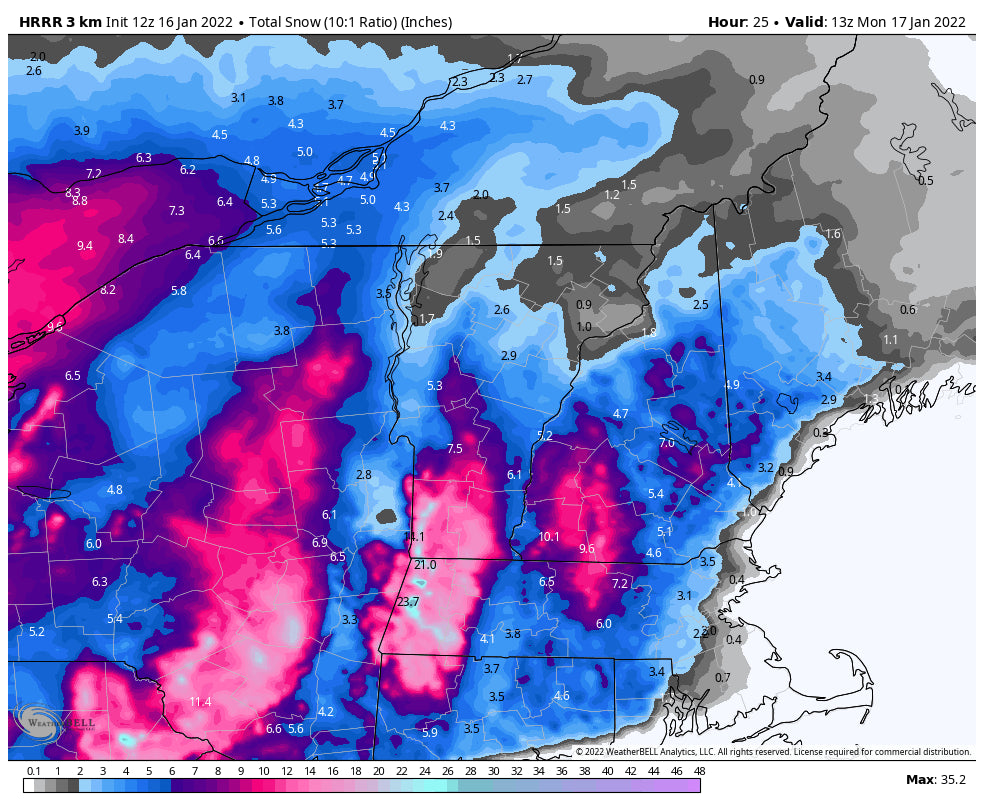
For New England temps are already starting to warm on Sunday with a vigorous system that swept from the Dakotas on Saturday through the Mid Atlantic and Southeast Sunday. It is dumping in North Carolina currently at the higher elevations. This storm will bring New England resorts 9-12 inches by Monday night at the summits with less snow at the bases due to warming and somewhat fluctuating snow levels (elevation dependent- snow, sleet, rain). Models show the highest amounts for Monday AM will occur over the Berkshires, Southern and central Vermont and most of the White Mountain Ranges of New Hampshire and western Maine. Stick south for Monday and head north Monday night where 3-6 additional inches will fall with colder temps and better quality (Northern resorts). Warm air will push in with strong winds Monday morning to most of New England bringing base temps too near or above freezing. Above freezing temps are noted south into MA and especially the coastal areas where rain will be falling. The western areas of New York and Canada will stay cold with better quality into Quebec.
Winds in southern and central New England will be very strong Monday morning so expect some delays. Models show these gusts increasing from south to north but decreasing by late morning (Things might be deep when or if they open. Bring the fat skis since the quality will be creamy).
Below: Short- term high resolution models show Monday morning in the New England to be deepest in southern Vermont, Western New Hampshire and the Berkshires. Snow will rapidly be moving north and east so by mid morning many ski areas will see heavy snowfall at the summits with a mixed bag possible at the bases. Winds will be strong early Monday morning. The Canadian border will see much colder temps so if you want high quality head to Canada!

NW winds Monday night will bring colder temps back to New England a bit more snow to Jay Peak, Stowe and the regions in northern Vermont and New York (Whiteface).
Extended:
Another storm will move into the interior of BC midweek with another round of light or moderate snow and slightly cooler temps then the above mentioned event Sunday/Monday. This may have better quality with perhaps 3-7 more inches for Whistler and the interior of BC. This storm will drop south over the northern Cascades and Rockies mid to late next week.
The northern Rockies and northern Cascades will likely feel the impacts of this event midweek (Whitefish will grab some light snow with heavier amounts east of the Ski Area). Snow will be falling over the southern Panhandle of Idaho (Light or moderate amounts) and trickle north into Sandpoint (Light), and further south over the interior of Montana. The Missoula areas mountains will get brushed with moderate snow (Eastern areas are favored) extending into Bridger Bowl (NW winds are a bonus) with lighter amounts. The American Model is showing moderate snow for the Tetons while others show light amounts by Friday. Some snow is also noted for northern Colorado near Steamboat. Bottom Line: The northern Rockies are likely to get teased mid- to late next week with some snow, however, amounts may be on the light side. Some models show moderate amounts into the Idaho Panhandle and perhaps the Tetons (This might be a stretch).
Below: Weak low pressure noted over the Rockies mid to late next week favoring Montana, Wyoming, eastern Idaho and Colorado. This is a not a game changer but could bring a few light or moderate surprises if lucky.

Below: The American GFS is the most optimistic next week for the Rockies while others show much lighter amounts. Glimmer of hope for some moderate snow for Idaho, Montana and perhaps the Tetons (Wildcard) with lighter amounts further south into northern Colorado. Remember- the other models show lower amounts so confidence is low this far out. Light snow is more certain with some chances of higher amounts.

Looking further afield, models show a glimmer of hope for a storm for the southern tier area of the 4 corners that might drop too far south of the ski areas (Central New Mexico). The are signals of a low pressure system approaching the Rockies at the very end of January or the 1st few days of February.
Below: Ensembles show a possible trough for the west at the end of January or early February (Low confidence this far out).

You can follow my travel/photo adventures on Instagram @powderchasersteve
Sign up for our Powder Concierge for the most custom forecasts, that will get you in the highest quality and deepest snow here. Or simply support our forecasts with a donation.
Let's hope that February comes in with a bang!
Powderchaser Steve


