SUMMARY:
Happy Winter Solstice! Winter has officially begun! Frustrations sum up my forecast for today with very warm air infiltrating the west. High avalanche dangers already exist in many locations with a significant amount of moisture aimed at the Pacific Northwest. A sharp cold front will crash temperatures downwards for the PNW and Rockies bringing snow to most locations.
Trip Report: Vail opened chairs 5 and 9 in the back bowls on Sunday with a limited selection of terrain. Being early season, and no real significant deep dumps in the northern mountains of Colorado this season, I was surprised how good conditions were. Vail has benefited from several light to moderate events recently and with the low sun angles, high elevation colder temps have held snow nicely at mid and upper elevations. The bowls opened at 9 AM, with me racing to Milts Face. The quality was 8/10, soft fluffy snow riding about a foot deep. Chair 9, also opened with great tree skiing. Other aspects of the bowls that face south are still in need of another dump (Headwall, Forever still closed). Riding from the summit of Vail to the base area was no problem (Riva Ridge).
Below: Vail- Yonder- Near Chair 9 - Photo: @Powderchasersteve via Instagram on my new Never Summer Harpoon.

The Chase? There is no ideal solution for the next few days. Significant moisture is falling in the PNW with warmer temps rising snow levels well above the bases of all Ski Areas in southern and central Washington. Snow levels will be lower in the northern Cascades, but the density will be high (Baker). The northern interior of the Washington Cascades may fare a bit better with cooler temps especially as you get closer to the Canadian border. Southern BC Interior Resorts (Red, Fernie, etc.) may score significant dumps in the next 24 hours! Schweitzer is a wildcard for Tuesday with the heaviest precipitation just north in Canada. Mt. Baker Ski Area might stay cold enough for primarily an all snow event (11-18).
* PNW- Colder temps move into the PNW late Monday afternoon improving quality with snow levels dropping significantly. Baker might ride soft and fluffy by last chair Monday on top of a cushion of wet snow. Monday night brings snow to even the foothills of Seattle. Moisture is tapering behind the cold front by early Tuesday morning. My best guess is widespread areas of 4-9 inches of decent quality snow for Tuesday morning along the western Cascades, with higher amounts in the interior north. 11-16 inches of wet snow will fall on Monday preceding the cold front above 4,000 feet in the north and at the summits of the ski areas further south (Rain/Snow event). While some ski areas will report 1-2 feet of snow up north (Storm total) the quality will be lagging until late Monday or Tuesday.
Below: Total combined snowfall from Monday/Tuesday for WA State. Wet dense snow initially up north (Rain to the south) will change to all snow Statewide by late Monday afternoon or evening.

Below: Monday temps are warm in Washington State except for the far northern sections, Canada, and even the Northern Pandhandle of Idaho near the Canadian border. Very cold air moves over the entire region Monday night into Tuesday.

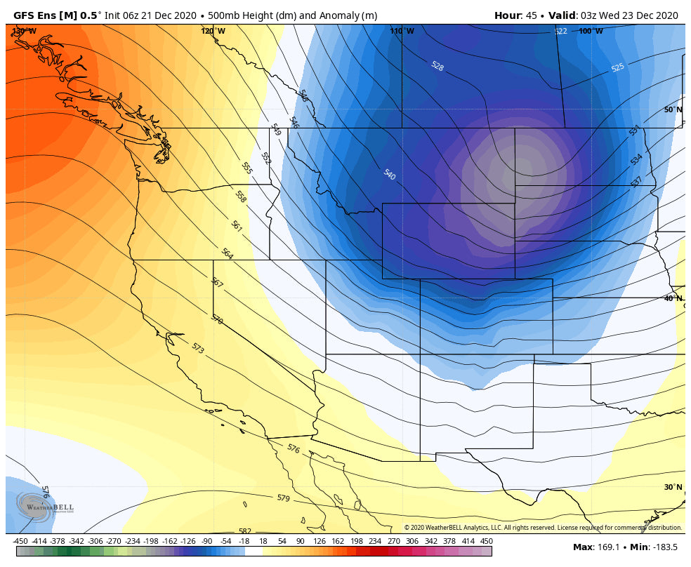
*Rockies- Elsewhere in the west, wet snow has fallen in the Tetons (Several 3-7 inch events in the past 2 days) with temps on the rise for Monday. Teton Pass was closed early Monday morning for avalanche mitigation. Colder air races down from Canada by Tuesday morning with light to moderate snow likely for the Tetons Tuesday, eventually clipping the Wasatch (Light). The track of this system while not overly strong will position from Wyoming through northern Colorado. Colorado grabs some freshies Tuesday night into Wednesday. While the moisture content is not impressive, the cold air alone might create some surprise totals for Steamboat, Vail Pass, and even Telluride to the south (Cold Air Orographics). Generally, resorts, along the I-70 corridor will all see some snow on Wednesday with 3-6 inches and some outlier surprises of 5-10 if the orographics come into play (Northern Mountains).
Below: Warm air in Wyoming and Utah will be replaced by a sharp cold front by Tuesday morning (Temps at 10K in Celsius).

Below: Low-pressure tracks over the northern Rockies favoring Wyoming and perhaps Colorado Tuesday/Wednesday albeit lacking significant moisture. Southern Montana will also see some snowfall. Utah will be clipped on the southern end.

Keep reading, as the extended has some glimmer of hope.
EXTENDED
We return to high pressure in the west as the PNW storm departs Monday and the Rockies on Wednesday. XMAS eve is likely to stay dry (Santa is delivering Online-Mail Order). Ahh, there is light at the end of the tunnel as the models depict a story period beginning in the west at some point around XMAS Day. There is a signal of a stormy period that returns to the PNW, Sierra, and Rockies at some point on or after December 25th. Optimism and the dreams of deep powder may soon return.
Below: High Pressure for the West midweek-XMAS Eve

Below: Return of a story period possible for the west towards the end of the week. These storms may drop further south than the previous ones this week.

Enjoy the powder everyone! Stay Safe! Please support our sponsors on the webpage and feel free to donate or join our Concierge program.
Powderchaser Steve


