Summary: Much colder temps, perhaps mid winter like in Canada will drop south over the Rockies and perhaps the Sierra mid or late next week. There are 2 systems we are following.
While temps are very warm this week, there are some big changes possible by the middle of next week. Forecast models 7 days out are not reliable but fo offer some good insight on a pattern change. Looking at low pressure in the upper atmosphere there should be a fast-moving front this weekend that tracks through central California and quickly pushes south over the 4 corners. Temps are still on the warm side, so the expectation is low for significant snowfall. Some rainfall is possible for BC and areas of the central or southern Rockies prior to a strong cold front and snowfall in the October 24-27 timeframe.
Storm #2 is the one to watch entering the Pacific Northwest early next week (Tuesday timeframe) with cooling temps and perhaps heavy snowfall.
Below: Storm #1 enters the Pacific this weekend with some moisture and fairly warm temps with little snowfall expected. This tracks south into Arizona. Some snow showers are possible in the higher elevations of the central or southern Rockies.

Below: Storm #2 has very cold air with snow levels dropping to the Valley floor in some locations of the northern Rockies. Currently, the highest chances of deeper pow exist in British Columbia (Whistler), Alberta, extending into the Cascades, Idaho, and Montana (Utah and Colorado are wildcards). The European model shows some hope for snow to reach the Sierra. It's too early to forecast the exact track this far out. We have high confidence in this pattern change, especially in the northern areas of the Rockies, PNW, and Canada but less confidence elsewhere.

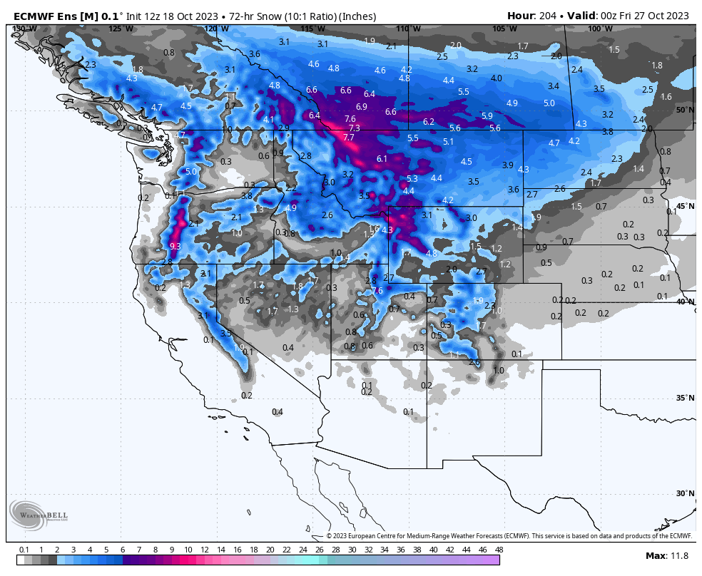
Below: European Ensemble (Multiple tweaks of operational models) is hopeful for storm #2 tracking into the PNW, Canada, and most of the Rockies mid to late next week. The Sierra is a wildcard at this point as models have been bullish previously. Higher confidence exists in the north.

Below: Here is the ensemble run from the GFS model with snowfall totals through next weekend October 29th, more focused on Canada and the northern Rockies. We can't provide much confidence in this model 7-10 days out. We have high confidence in the pattern change (Cooler and snow) likely favoring northern areas of the west including Canada.

Below: This map on October 26 (next Thursday) is at 4800 feet showing very cold temps for Alberta and interior BC (-12C). Temps in coastal BC will also cool with expected snowfall. The Cascades are cooling by Tuesday afternoon next week into Wednesday (October 25) lowering snow levels to the bases at many ski resorts later in the storm cycle. BC might be the biggest winner on snowfall (Watch for Whistler or perhaps Alberta resorts) with very cold temps extending from Canada into the northern Cascades and Montana. (Bright green colors).

Below: The cold front reaches the Rockies mid-next week. This might take a more inland track over Idaho, Montana, and Wyoming with Utah and Colorado wildcards. The Sierra remains on the southern edge of the cold front and will cool late next week. You can see 10K temps as low as -13C degrees In Canada and the Northern Rockies which would be more typical of mid-winter. Odds of snowfall increase in many areas mid to late next week with this cold air. The map is from Wednesday night October 25 to Friday, October 27 PM next week.

We will update this post as the models come into better agreement. You can follow my passion for photography and chasing powder on Instagram @powderchasersteve
Here is my favorite picture I took in Alaska. These bears say "Snow is coming" Please check out our top pick in Alaska for Heli Skiing and receive a free Powderchasers concierge package at Alaska Backcountry Guides when booking. They still have seats available for this winter.

Please sign up for our new Concierge packages to support us and chase the deepest storms of the season. We now offer full trip planning including airfare, lodging, and of course your top spots for the deepest pow. You can sign up here for our newest Powder Concierge programs. There are 4 new options to look at this season.
Thanks for following Powderchasers. We will update this forecast in the next few days.
Powderchaser Steve


